SHARE PRICE:
Gawler Iron Project

The Gawler Iron Project has the potential for a small 1-2 Mtpa development that may provide early sustaining cash flows. Following successful completion of an earn-in, Iron Road now holds 90% of this project. A scoping study is now underway and is expected to be completed in mid-2013.
Preliminary test work indicates excellent beneficiation characteristics, with of results of 67-71% Fe recorded at a grind of -106 micron (p80). Overall, a high quality iron concentrate is expected, with similar characteristics to CEIP product specifications.
Conceptually, Iron Road is considering a modular plant layout, with the majority of the modules and equipment designed for rail transport. The Gawler Iron project is approximately 25 km from the Trans Australian rail network, which links to multiple bulk ports.
A dry process flow sheet will be considered, minimising the project water requirements and costs associated with water supply.
Prior to Iron Road, the area had not been systematically explored for iron ore despite reconnaissance drilling of surface outcrops by the South Australian government in the 1960’s that identified several BIF-hosted iron deposits.
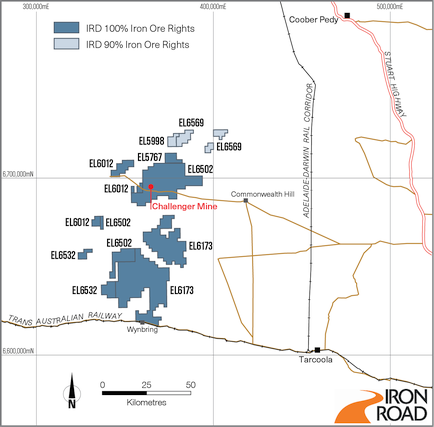
The Gawler Iron Project is in South Australia, located along the eastern margin of the Great Victoria Desert some 200 kilometres southwest of Coober Pedy. The project tenements abut the Trans Australian Railway and are within 100 kilometres of the Adelaide-Darwin Railway. The Gawler Iron Project fits very well with Iron Road’s flagship Central Eyre Iron Project project and the Company’s strategy of investigating advanced exploration projects in close proximity to existing infrastructure.
The Project area covers 3380km² and includes over ten areas of known iron occurrences, including the Mt Christie deposit which was the subject of beneficiation test work in the 1960’s by the South Australian Department of Mines.
Exploration History
Scattered outcrops of magnetite-rich gneiss and metamorphosed banded iron formation (BIF) have been known of since the late 1800’s. The area attracted the attention of the Mines Department in the late 1950’s. A programme of reconnaissance outcrop mapping and sampling was instigated, followed by a drilling programme of three diamond holes to test the main outcrops of iron formation. A modest resource of 15-20Mt averaging 35% Fe was published and beneficiation test work produced concentrates of 56 - 65% iron (Fe) and recoveries of 70 - 90%.
At Black Fellow Hill mineralisation consists of two, sub-cropping horizons of iron formation. Historic drilling returned grades of 46.8% Fe. George Hill and Claude Hill are two banded iron formations located in the keel of a syncline. Historic drilling intersected iron mineralisation at a down-hole depth of 15 - 40 metres and returned an assay of 49.9% Fe.
Important note.
The information in this report that relates to Exploration Results is based on and accurately reflects information compiled by Mr Larry Ingle who is a fulltime employee of Iron Road Limited and a Member of the Australasian Institute of Mining and Metallurgy. Mr Ingle has sufficient experience relevant to the style of mineralisation and type of deposits under consideration and to the activity, which he is undertaking to qualify as a Competent Person as defined in the 2004 Edition of the “Australasian Code for Reporting of Exploration Results, Mineral Resources and Ore Reserves”. Mr Ingle consents to the inclusion in the report of the matters based on his information in the form and context in which it appears.